
Only one walk in town stirs up so much controversy among long-time locals and newbies alike: the pilgrimage to the Mendenhall Glacier.
This winter (way back in February…) I made the decision to venture out across a frozen lake towards the Mendenhall Glacier. We had a few weeks in a row of very chilly temperatures, and there was a mass pilgrimage among locals to the glacier to see it up close, and get a peek at the incomparable blue glowing ice caves. In addition to being spectacularly beautiful, a lot of people in town have strong feelings about the trek.
The trek
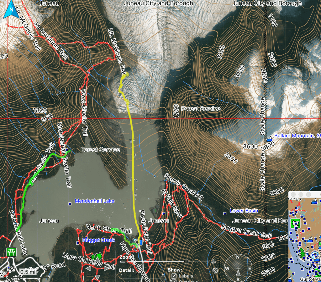
Mendenhall Glacier is situated in a carved out valley with a large lake (where the glacier used to be before melting back). There are parking lots at the south ends of the two lake lobes, and everything else is accessible by hiking, or kayaking (sure, or flying).
To get to the glacier most of the year usually requires a lengthy and treacherous hike on the west side of the lake. You can see my neon green hike to the halfway point on the map. There is a sign on the trail that cautions hikers of the dangers of getting lost or stuck, and requiring search and rescue. It’s not easy to get to the glacier.
In the winter, however, a much more direct path to the glacier is available – straight across the frozen lake (see the yellow like path on the map). Even this direct route is about 2 miles each way. Once you reach the glacier, there is a path along its west side on rocky ground. The aerial image from the map above is old. When I visited, my path was entirely clear of glacier ice. The face of the glacier is probably about where the line goes from straight to curvy.
Safety.
We might as well get this out of the way – glaciers are not safe! They are massive, and always moving. They are defined as “a river of ice”, a difficult concept to wrap your head around. I think of it like the backwards lava of the north?
At any rate, Some of the ways glaciers are not safe include:
- Calving – when a big chunk breaks off of the front of the glacier and splashes down into the water. Depending on the size, the waves alone could be a problem for you if you’re on the lake. If you’re standing close to the face of the glacier, obviously you don’t want a giant slab of ice to fall on you. As a result, the face of the glacier is regarded as quite dangerous, yet people still insist on approaching it because it is clearly spectacular.
- Crevasses – Looking at an aerial of a glacier you’ll see that it’s basically a series of cracks and tall fins. The cracks are called crevasses and they can be really really deep. What makes this particularly dangerous is the fact that glaciers are often covered in superficial layers of snow and ice so you can’t really see where you’re walking. You won’t catch me on top of a glacier anytime soon.
- Caves Collapse – Ice “caves” are hollowed out sections inside glaciers, usually formed by melting water carving out areas inside the ice. They are… breathtaking sirens of doom. In the weeks leading up to my hike, the local photo page was flooded with gorgeous other-worldly images on beautiful glassy bright blue caverns. “I want to be there” is the only natural response. Unfortunately, ice caves are subject to sudden collapse like… any time, because the glacier ice is always moving and shifting. Obviously being crushed, or trapped, inside and ice cave is not ideal.
- Falling through the ice (ok I ran out of Cs) – Did I mention that the walk from the parking lot to the peninsula next to the glacier is about 2 miles in a straight line across the lake? This is the alternative to a much longer, rocky and rugged hike when the ice path is not an option. You’d think that a lake in Alaska, in the winter, with a giant ice cube in it being frozen solid is a sure thing, but it’s really not. Not only is there a massive waterfall that drains into the lake and undermines the ice, but the thick layer of snow cover sometimes inhibits ice formation. So, there’s that to worry about.
- Iceberg, dead ahead! – Icebergs aren’t just a problem if you’re the Titanic. After breaking off of the glacier, they float on the lake. When the lake surface freezes, it does not freeze as firmly around icebergs. They also shift and move because they’re floating. Avoid the icebergs.
The local community approach seems to fall anywhere from “hell no, I won’t go ever” to “heck, I’ve walked out there every year since I was five, it’s totally safe”. People insisting that their behavior was excessively risky citing past tragedies faced off against people who insisted they knew better on local discussion boards.
Of course there’s no way to be sure. There are definitely risks, and there are definitely ways to mitigate risks. I chose to go only once the temps had been very well below freezing consistently for a few weeks, went while there were lots of other people around, did some research on the risks, followed a local group that did some ice measurements, stayed off of the top of the glacier, and didn’t venture into ice caves beyond a few feet to snap a picture and move on. We’ll never know if it was the right call.
Receding glaciers.
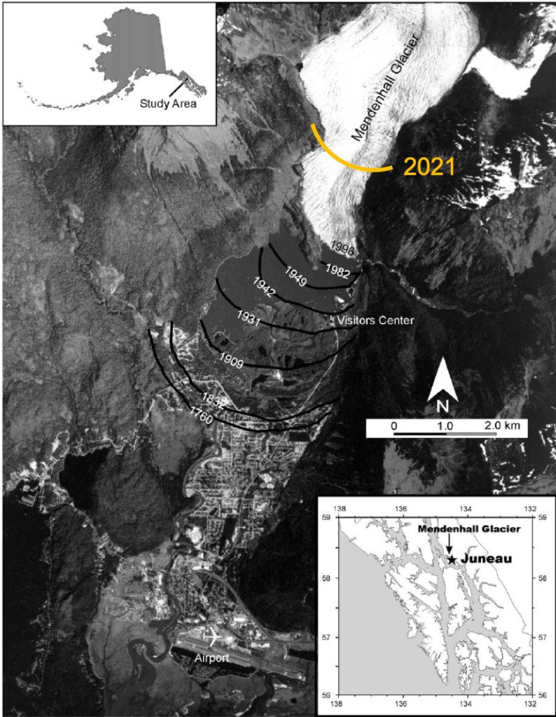
If you stand where the visitor center is, it will surprise you to know that the glacier used to be within a quick walk away, rather than the nearly 2 miles it is now.
Interpretive signs and year posts along the trails who where the glacier used to be. Local lifetime residents recall visiting the glacier when it was seemingly within arms reach. I was here in 2012(?), and even I can see the difference.
As the glacier recedes more and more, the ice caves become less accessible and more treacherous for casual visitors to enjoy. Glacial melt increases water volumes in the lake and river downstream.
There’s an interesting research paper about the glacial melt here:https://www.researchgate.net/publication/233761155_Changing_Lake_Bathymetry_with_Deglaciation_The_Mendenhall_Glacier_System
Climate change is a hot topic in Alaska as we’re a traditionally conservative state, but also have entire communities falling into the ocean, rivers, and lakes where water levels are rising and permafrost is no longer perma(nent).
Fun.
Controversies aside, the experience was pretty incredible, in the true sense of the word. I woke up, layered up, packed up my camera, drove about 5 minutes to the parking lot, then walked across a frozen lake with hundreds of other people. Within about an hour I was able to see a glacier up close – nay – touch one. Spoiler alert – it was cold.
For the full album of photos, check out my album on Flickr: AK.Mendenhall Glacier and Ice Caves.

Thanks for sharing! Always love your blogs!
Did you take many of those photos with your flying camera? Photos were spectacular, some made me a little uneasy, like too up close and personal. Great photography!
Turning into spring here, sporadically between freeze /frost warnings and downpours of hail!
Take care, keep in touch. Love, Sharon
LikeLike
Thanks! I did not take the drone out this day. I’m sure I could have gotten some spectacular views, but it was out of service at the time. We’re enjoying signs of spring here too, with a few frosts this week. I had to bring in some of the plant babies.
LikeLike
This is spectacular. Still wrapping my head around the black parts of the glacier. Also the cave looks un-walkable (like a river/lake on bottom). Will have you explain that to me later lol.
LikeLike
There was indeed about a foot of slush water in the bottom of the cave which helped make the decision not to go in much easier. Just a week before the ground was frozen solid. All those hot bodies didn’t help, I’m sure…
LikeLike